Blizzard Warning
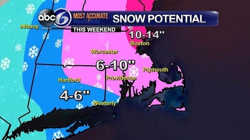
A Blizzard Warning has been issued for all of Eastern MA, Cape and Islands effective 7pm Saturday until 1pm Sunday. The worst of the snow will be Saturday night. The worst of the wind (and therefore the worst of the visibilities and sub-zero wind chills) will be during the day Sunday. Expect 8 to 10 inches snow in the Blizzard Warning areas, which include Bristol and Plymouth counties in MA. The north winds will gust up to 60mph (70 mph on the Cape), producing life-threatening, whiteout conditions on the roads. The winds will be with us into Sunday afternoon, and that’s when the snow tapers off as well. Coastal flooding is likely Sunday on the E MA coast, especially on Cape Cod Bay.
As for Rhode Island, a Winter Storm Warning goes into effect 3pm Saturday until 1pm Sunday. We can expect 6 to 10 inches of snow across the state. The heaviest of fhe snow will come Saturday night, with the strongest winds coming on Sunday. We will also have very dangerous driving conditions, especially on Sunday when the winds dramatically increase. We can expect north wind gusts from 45-55mph, with the highest gusts on the coast. The snow tapers off Sunday afternoon, but it stays windy with sub-zero wind chills and blowing/drifting snow.
Also, a Coastal Flood Advisory has been issued for Sunday morning’s high tide for the east coast of MA including the Cape, especially Cape Cod Bay.
Expect wind chills at or below zero through today and tonight, with overnight lows from zero to 5 below, although winds will diminish later this evening.
Saturday starts out very cold, with light winds. The breeze freshens by the afternoon, with highs in the mid to upper 20s. Snow should arrive from the SW by Saturday afternoon, with some accumulation possible by evening. The snow and wind will pick up Saturday night into Sunday morning, with moderate to heavy snow accumulations likely, coupled with 50-70 mph NNW wind gusts, near-zero visibilities and sub-zero wind chills. Sunday brings light snow and strong wind for much of the day, not clearing until late in the day with the wind still with us. Totals should add up to at least 6″ for most, higher amounts to the east, lesser amounts to the west.
Kevin Coskren, ABC6 StormTracker WeatherTeam