All eyes on weekend storm
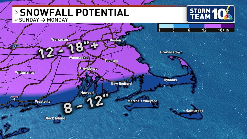
Lovely afternoon with plenty of sunshine. Temperatures are on the chilly side but seasonable in the low-40s. High pressure remains in control. Clouds increase overnight with a chance to see some flurries tomorrow morning. It will remain mostly cloudy. Temperatures will tumble as a dry cold front pushes through. Thursday night though Saturday should remain dry and cold. Prepare for the chill, wind chill that is…Friday morning will be in the single digits. Be ready for that cold. Now to the story headlining weather these days…the weekend coastal storm. Here’s the latest. We’re expecting to see some precipitation by Saturday night into Sunday night. This will be an impactful storm that will trigger hazardous conditions on the roads. There is considerable uncertainty on the track and intensity…pinpoint rain/snow line. May see more of a mix situation along eastern MA, southern RI and CT at the start of event on Saturday night. Sunday afternoon may see the changeover with heavy snow for some. Sunday night the concern is the freezing temperatures, any area that received mix or rain may see a freeze. At this time it’s too early to determine specific snow totals. There is 40-50% probability to receive 6″+ over northern Rhode Island. Providence’s chance is 30-40%. Southern parts of our state, less of a probability. There is 50-70% probability to receive 3″+ over central to norther Rhode Island. For now, stay tuned as we are a few days out. In the meantime, bundle up this morning and enjoy the sunshine.