Wet weather on the way tonight and tomorrow
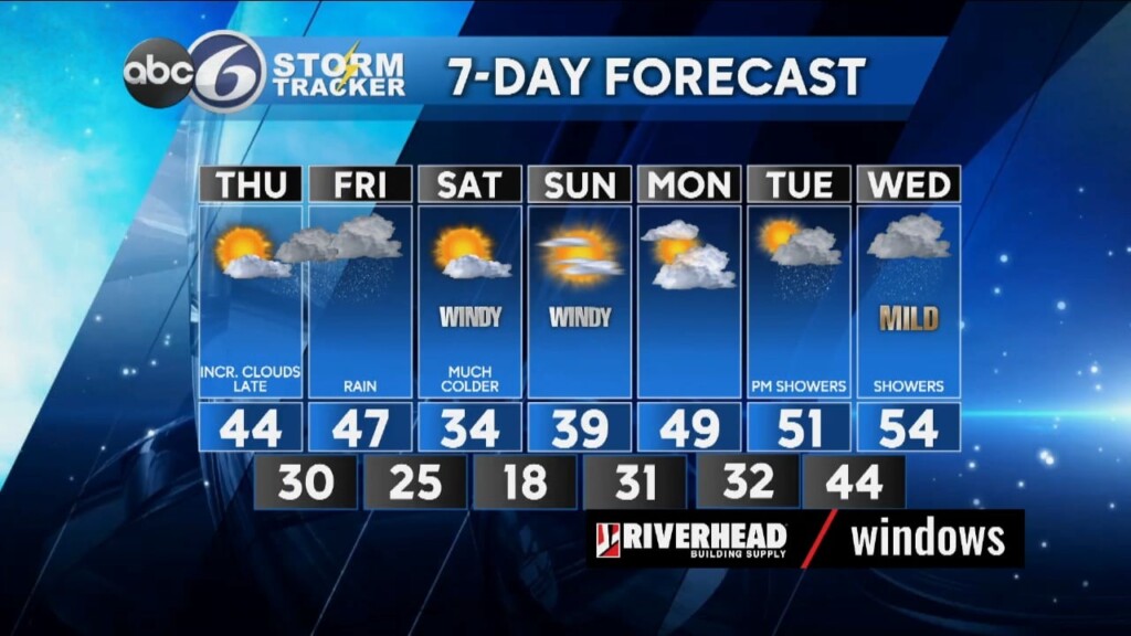
We’ll see a good deal of sunshine today with temperatures climbing into the low 40s this afternoon. An approaching warm front will bring increasing high clouds later this afternoon and then thickening early this evening. Watch for some light rain showers to develop later this evening around and after 10 PM that may mix with some wet snow across the northern part of RI and up into Worcester county, continuing into early Friday morning. I don’t expect any accumulations because temperatures will stay just above freezing, but that said there could be some isolated slippery spots on untreated roads.
As we wake up Friday morning the sky will just be cloudy, but as Low pressure works its way across southern New England heading up toward Nova Scotia we’ll see periods of mostly light rain for the late morning and afternoon hours that’ll come to an end by the early in the evening. Highs tomorrow will be in the mid to upper 40s.
High pressure will return for the weekend, accompanied by colder and windy conditions. Highs will be back in the low-mid 30s Saturday, but gusty winds between 25-30MPH will make it feel like it is in the low-mid 20s. More sunshine is on tap for Sunday with highs climbing to the upper 30s, but that is still below normal. However, we move into next week and finish the month of February we’ll be warming into the 50s!
ABC6 Meteorologist Bill Gile