Cold and Windy Weekend
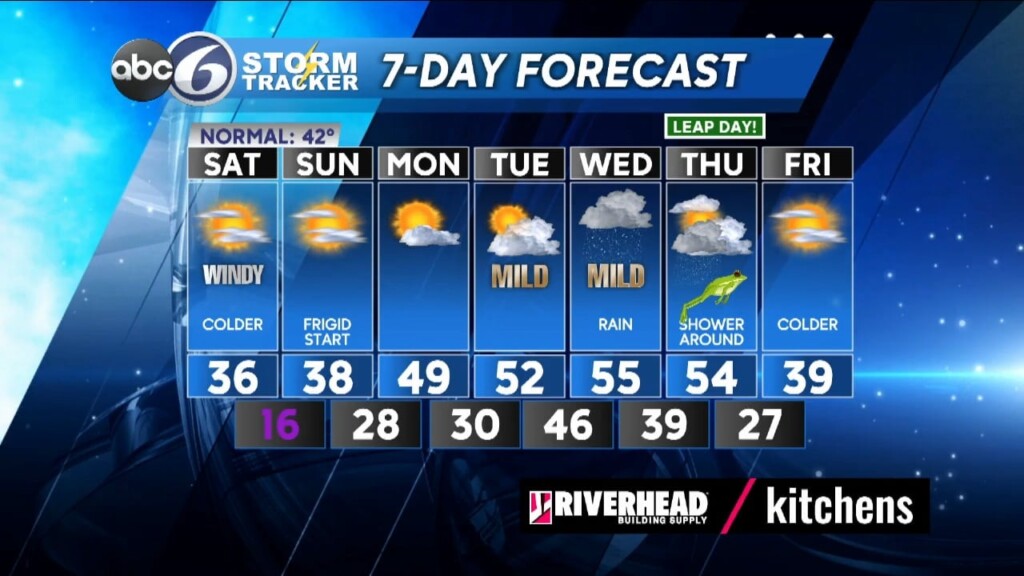
After a wet Friday, clouds will linger through the overnight and there will still be moisture leftover in the form of patchy fog. Temperatures will slowly drop to near freezing just before daybreak tomorrow morning in northern & western RI and up into Worcester county and it’ll be in these areas that some surfaces may still be damp enough to result in spots of black ice to start the day. So, if you are traveling on the roads in those areas be aware that there could be some slippery spots on untreated surfaces. From Providence southward temperatures will start the morning off just above freezing so you’ll be ok.
Look for a fair amount of sunshine Saturday with a few clouds, but it will be colder with highs only in the mid 30s and a blustery wind from the NW at 12-25mph. That wind will make it feel like the lower 20s. High pressure builds overhead Saturday night and then it really gets cold as lows drop to the teens for Sunday morning along with a persistent breeze that will give us wind chills in the single digits. Sunday itself will be sunny, but highs will be stuck in the upper 30s.
An approaching front will bring some clouds to start our Monday morning, but then the sky cover will improve Monday afternoon along with the start of a warming trend that will last until the end of February. However, there will be rain coming our way for Wednesday and a lingering shower or two Thursday.
ABC6 Meteorologist Bill Gile