Sunshine Friday before the storm late night into Saturday morning
Fabulous Friday with plenty of sunshine today with temperature in the mid-40s. Clouds will increase ahead of the next powerful and robust storm late tonight into tomorrow morning. A Coastal Flood Warning has been issued and will go into effect Saturday 7 a.m. to 1 p.m. that may lead to a moderate impact around high tide 9 a.m. which could generate 2-3′ feet inundation.
Roads may be impassable for a few hours at time of high tide. Beach erosion is also a possibility. A Flood Watch has been extended through Saturday evening due to rain received and incoming as well as the snowmelt. This will renew or worsen the risk for areal, river, and creek flooding. Area rivers may rise back rapidly to flood stage Saturday. The concern remains for the Pawtuxet River, Wood River, Pawcatuck River, Shawsheen River, and Housatonic River. Also, a Wind Advisory will go into effect Saturday from 1 a.m. to 1 p.m. sustained SE 25-35 miles per hour with gusts up to 55 miles per hour that may lead to power outages.
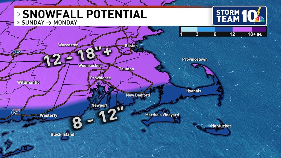
Rain exits the area by mid to late morning with windy condition extending into Sunday. Temperatures will also fall Saturday night to freezing that could freeze any standing water. Sunday afternoon we could see some passing snow/mix showers; however, it will be mostly sunny and cold, mid to upper 30s. Cold and partly sunny Monday, Martin Luther King Day. Cold temperatures will prevail through the week with a potential snow/rain storm Tuesday into Wednesday.