Weather improves after morning storm with frigid air arriving for next week
Rain has tapered to just some showers and drizzle across the area, with sunshine breaking out this afternoon.
Breezy conditions will continue through the weekend, with colder air coming in by Sunday.
Wind gusts reached 50-60 mph last night, which led to dozens of power outages along the south shore.

As of 11:30 AM, Rhode Island Energy reported around 175 active outages. The new gusty winds and loose soil may have further compromised many trees from the storm earlier this week.

Temperatures are starting off in the 50s today, but will fall later this afternoon and into tonight. Watch for icy spots from standing water.
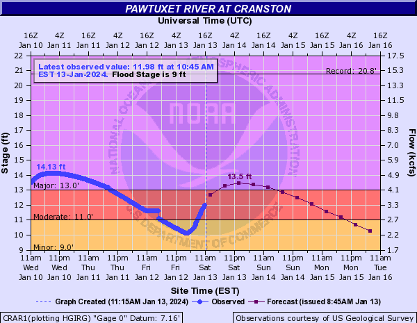
Our rain forecast verified nicely with .5-2″ falling across the area.

This will spike our river levels back into flooding stage tonight into Sunday morning before finally receding out of significant flood stage by Monday.

An arctic cold front on Sunday could bring a brief rain or snow shower or even a snow squall.
A snow squall is a fast-moving snow shower that produces heavy snow and wind for 10-15 minutes
This will usher in even colder air into Martin Luther King Day on Monday.
With very cold air in place, we are keeping an eye on a few pieces of energy that could form into storms and bring snow.
STAY WITH ABC6 NEWS