Wintry mix Saturday night, more snow to come Sunday
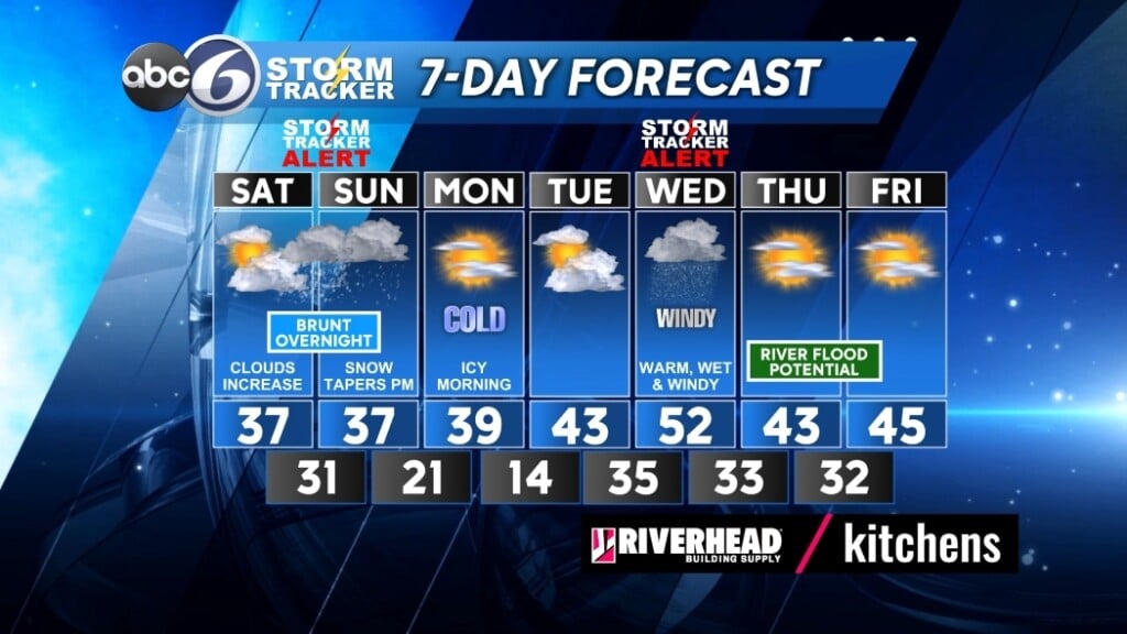
The winter storm is still on track for this weekend. Cloudy and dry conditions through early evening will help get preparations completed. Snow is expected to develop through the evening hours and quickly become heavy through about 3 am. This will be the height of the storm when accumulations will pile up and roads become hazardous. In the interior of Southern New England, it will remain entirely snow and this is where we could pick an impressive 6-12”. A Winter Storm Warning is in effect for north and western Providence County as a result.
A Winter Weather Advisory is in effect for Providence and the rest of southeastern Southern New England, because in this area, there is an element of mixing with rain expected. Snowfall amounts will drop off rapidly as you head to the coast. Along the coast, winds will pick up and gusts are expected of 30-40 mph through Sunday. Power outages are possible. In the end, it all comes down to the positioning of the rain/snow line. As of this update, plan on 3-6” for Providence and Kent County and 2-4” for the coast. The snowfall lets up Sunday morning and we are expecting a little break before another round of snow goes through the remainder of the day.
A big concern is a rapid drop in temperatures on Sunday that will cause a flash freeze. Anything wet will become icy as temperatures crash. Roadways will become hazardous Sunday late morning through Monday morning. Winds will still be blustery and wind chills will crash to near 10 degrees Sunday. All snowfall comes to an end Sunday evening and skies finally clear. Overnight lows will drop into the teens for Monday morning.
Sunshine returns for a chilly Monday and conditions remain dry for most of Tuesday. Rain develops for Tuesday evening and will become heavy through Wednesday. This is shaping up to be another wind-driven rain event and localized flooding will result.
We will have the opportunity to dry out Thursday and Friday.